Every land development project, whether for housing, commercial use, or infrastructure, begins with ambition and investment. Yet, it is no secret that development is both high risk and high cost. Even the smallest site issues a misjudged boundary, an overlooked slope, or an unrecorded structure can snowball into major delays, redesigns, and unexpected expenses.
In the UK, developers face increasing demands from planning authorities, rising construction costs, and heightened scrutiny on compliance. With so much at stake, the margin for error is slim. This is why the first step of any responsible project is not design or construction, but accurate measurement and recording of the site itself.
A topographical survey provides this foundation. By documenting every natural and man-made feature of a site, it gives architects, planners, and contractors the clarity they need to make informed decisions. Without it, development becomes guesswork—something no investor can afford.
What is a Topographical Survey?
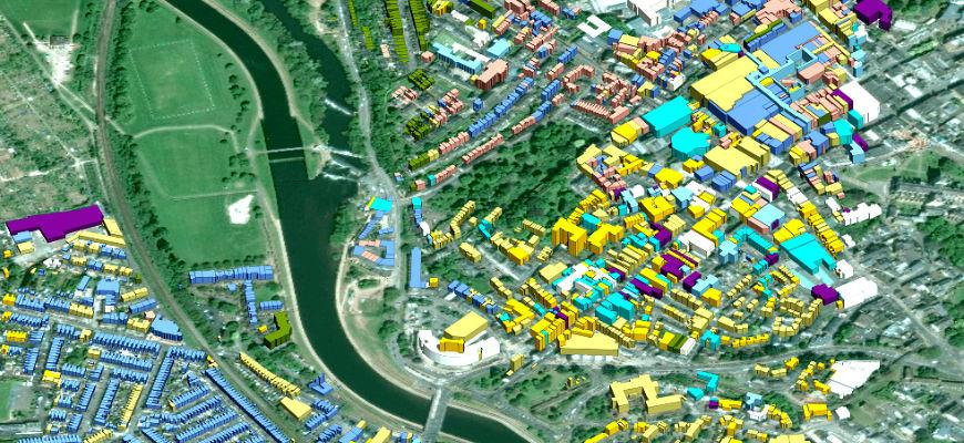
A topographical survey is a highly detailed map of a piece of land. Unlike a simple sketch or title plan, it shows the precise position of boundaries, ground levels, existing buildings, trees, drainage features, access roads, and any other physical details of the site.
This information is gathered using surveying equipment, digital scanners, or drones, depending on the project. The data is then processed into clear drawings or digital models that can be shared across the project team.
For anyone involved in development, this survey is the reliable “blueprint” of the land as it exists today. It ensures that decisions are based on facts, not assumptions. Commissioning topographical surveying at the outset provides clarity and confidence, laying the foundation for smoother designs and approvals.
Why Land Development Projects Need It
- Prevents costly design errors
Architects and engineers depend on accurate data. If the ground levels or features are misrepresented, designs may not fit the reality of the site. A topographical survey ensures designs are practical from the start. - Supports planning applications
Planning authorities often request detailed site information. Submitting a topographical survey speeds up the process and demonstrates professionalism. - Reduces risk of disputes
Boundaries and ownership can be contentious. A survey provides clear, verifiable evidence of land limits, reducing the chance of neighbour or legal disputes. - Protects budgets and timelines
Unexpected discoveries like underground drainage or a hidden slope can derail projects. A survey highlights these early, so solutions can be planned before costs spiral.
In short, without a survey, developers are working blind. With it, risks are identified early, and designs can move forward with confidence.
Key Benefits for Developers & Planners
For professionals in development, the advantages of commissioning a topographical survey are immediate and measurable:
- Faster planning permission
- Applications supported by accurate survey drawings are more likely to be approved quickly. Authorities see them as reliable evidence.
- Accurate cost estimation
- Contractors can price works with precision, reducing the likelihood of budget overruns caused by unforeseen site issues.
- Improved collaboration
- Survey data is easily shared in CAD or BIM formats, allowing architects, planners, engineers, and contractors to work from the same reliable source.
- Better risk management
- Early identification of hazards, boundaries, and existing structures allows teams to mitigate problems before they become costly delays.
This list alone shows why developers increasingly see surveys not as an expense but as an investment in project success.
Modern Surveying Methods
Surveying has advanced far beyond tape measures and sketches. Today, developers benefit from methods that are both faster and more accurate:
- Laser scanning captures millions of data points in minutes, producing highly accurate 3D models of terrain and structures.
- Drone surveys allow safe, rapid data collection over large or inaccessible sites.
- CAD and BIM outputs provide digital files that slot directly into architects’ and engineers’ workflows.
Compared to traditional methods, modern surveying reduces human error, shortens project timelines, and produces outputs that can be reused throughout the design and construction phases.
Conclusion
No matter the size or scope of a project, starting without a topographical survey is a risk few can afford. From planning applications to construction and long-term management, accurate site data underpins every stage of development.
By commissioning a professional survey at the very beginning, developers secure clarity, compliance, and confidence. In a world where every delay costs money and every error invites risk, one fact remains clear: successful land development begins with a topographical survey.